
Thank you for supporting this site ❤️
Make a donation
Make a donation
Rest Haven topographic map
Click on the map to display elevation.
Thank you for supporting this site ❤️
Make a donation
Make a donation
About this map
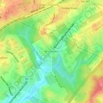
Name: Rest Haven topographic map, elevation, terrain.
Location: Rest Haven, Gwinnett County, Georgia, United States (34.12701 -83.98445 34.13920 -83.96896)
Average elevation: 349 m
Minimum elevation: 315 m
Maximum elevation: 388 m
Thank you for supporting this site ❤️
Make a donation
Make a donation
Other topographic maps
Click on a map to view its topography, its elevation and its terrain.
Thank you for supporting this site ❤️
Make a donation
Make a donation
Rock Creek Estates
United States > Georgia > Gwinnett County > Buford > Rock Creek Estates
Average elevation: 338 m
Thank you for supporting this site ❤️
Make a donation
Make a donation
Settles Bridge
United States > Georgia > Gwinnett County > Suwanee > Settles Bridge
Average elevation: 314 m