
Thank you for supporting this site ❤️
Make a donation
Make a donation
Saint Francis topographic map
Click on the map to display elevation.
Thank you for supporting this site ❤️
Make a donation
Make a donation
About this map
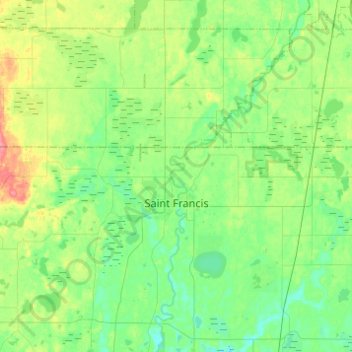
Name: Saint Francis topographic map, elevation, terrain.
Location: Saint Francis, Anoka County, Minnesota, 55070, United States (45.37787 -93.51007 45.42076 -93.26532)
Average elevation: 282 m
Minimum elevation: 262 m
Maximum elevation: 329 m
Thank you for supporting this site ❤️
Make a donation
Make a donation
Other topographic maps
Click on a map to view its topography, its elevation and its terrain.
Rum River North County Park
United States > Minnesota > Anoka County > Saint Francis
Average elevation: 279 m
Thank you for supporting this site ❤️
Make a donation
Make a donation