
Thank you for supporting this site ❤️
Make a donation
Make a donation
Island Falls topographic map
Click on the map to display elevation.
Thank you for supporting this site ❤️
Make a donation
Make a donation
About this map
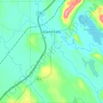
Name: Island Falls topographic map, elevation, terrain.
Location: Island Falls, Aroostook County, Maine, 04747, United States (45.94385 -68.29984 46.03759 -68.16698)
Average elevation: 159 m
Minimum elevation: 128 m
Maximum elevation: 313 m
Thank you for supporting this site ❤️
Make a donation
Make a donation
Other topographic maps
Click on a map to view its topography, its elevation and its terrain.
Saint John River
United States > Maine > Aroostook County > Fort Kent
The eastern Algonquin languages had different dialects associated with each of the major river systems of New England and the Maritimes; and there was often a linguistic bifurcation between residents of the upper river and those living along the coast and tidal estuary. The Passamaquoddy hunted sea mammals…
Average elevation: 208 m