
Thank you for supporting this site ❤️
Make a donation
Make a donation
Lanvar topographic map
Click on the map to display elevation.
Thank you for supporting this site ❤️
Make a donation
Make a donation
About this map
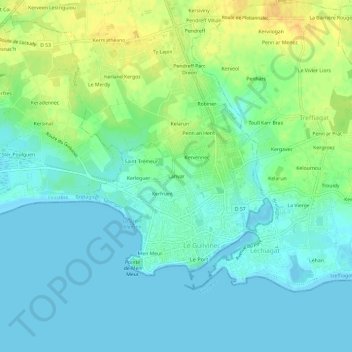
Name: Lanvar topographic map, elevation, terrain.
Average elevation: 9 m
Minimum elevation: -2 m
Maximum elevation: 27 m
Thank you for supporting this site ❤️
Make a donation
Make a donation
Other topographic maps
Click on a map to view its topography, its elevation and its terrain.
La Grève blanche
France > Bretagne > Finistère > Guilvinec > Le Guilvinec > Men Meur
Average elevation: 5 m