
Thank you for supporting this site ❤️
Make a donation
Make a donation
Charaideo topographic map
Click on the map to display elevation.
Thank you for supporting this site ❤️
Make a donation
Make a donation
About this map
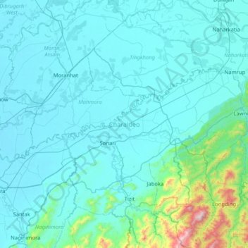
Name: Charaideo topographic map, elevation, terrain.
Location: Charaideo, Assam, India (26.91296 94.73459 27.22661 95.37174)
Average elevation: 212 m
Minimum elevation: 92 m
Maximum elevation: 1,657 m
Thank you for supporting this site ❤️
Make a donation
Make a donation
Other topographic maps
Click on a map to view its topography, its elevation and its terrain.