
Thank you for supporting this site ❤️
Make a donation
Make a donation
Cilebak topographic map
Click on the map to display elevation.
Thank you for supporting this site ❤️
Make a donation
Make a donation
About this map
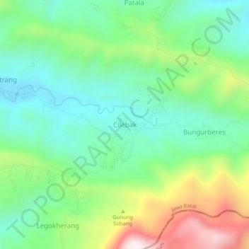
Name: Cilebak topographic map, elevation, terrain.
Location: Cilebak, Kuningan, West Java, Java, Indonesia (-7.15606 108.56370 -7.11606 108.60370)
Average elevation: 620 m
Minimum elevation: 360 m
Maximum elevation: 1,172 m
Thank you for supporting this site ❤️
Make a donation
Make a donation
Other topographic maps
Click on a map to view its topography, its elevation and its terrain.