
Thank you for supporting this site ❤️
Make a donation
Make a donation
Lirung topographic map
Click on the map to display elevation.
Thank you for supporting this site ❤️
Make a donation
Make a donation
About this map
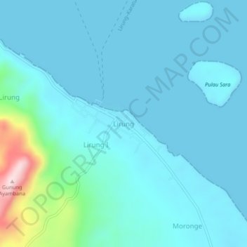
Name: Lirung topographic map, elevation, terrain.
Location: Lirung, Talaud Islands, North Sulawesi, Sulawesi, Indonesia (3.91649 126.67846 3.95649 126.71846)
Average elevation: 40 m
Minimum elevation: 0 m
Maximum elevation: 328 m
Thank you for supporting this site ❤️
Make a donation
Make a donation
Other topographic maps
Click on a map to view its topography, its elevation and its terrain.
Thank you for supporting this site ❤️
Make a donation
Make a donation
Thank you for supporting this site ❤️
Make a donation
Make a donation
Thank you for supporting this site ❤️
Make a donation
Make a donation
Bogani Nani Wartabone National Park
Indonesia > North Sulawesi > Bolaang Mongondow Utara
Average elevation: 186 m