
Make a donation
Saratoga County topographic map
Click on the map to display elevation.
Make a donation
Saratoga County
Saratoga County is situated in the eastern portion of New York State, north of the state capital city of Albany, northwest of Troy, and east of Utica. According to the U.S. Census Bureau, the county has a total area of 844 square miles (2,190 km2), of which 810 square miles (2,100 km2) are land and 34 square miles (88 km2) (4.0%) are covered by water. The Hudson River forms the eastern border of the county, while the Mohawk River demarcates its southern border. The highest elevation in Saratoga County is at the peak of Tenant Mountain in the Adirondack Mountains, at 2,759 ft (841 m), while the lowest elevation is 69 ft (21 m), at the waterfront of the Village of Waterford, at the confluence of the Mohawk and Hudson Rivers.
Make a donation
About this map
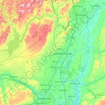
Name: Saratoga County topographic map, elevation, terrain.
Location: Saratoga County, New York, United States (42.77529 -74.16011 43.39770 -73.57332)
Average elevation: 218 m
Minimum elevation: 3 m
Maximum elevation: 833 m
Make a donation
Other topographic maps
Click on a map to view its topography, its elevation and its terrain.
Make a donation
Make a donation
Chester Heights
United States > New York > Westchester County > City of New Rochelle
Average elevation: 36 m
Make a donation
Black Creek Village
United States > New York > Niagara County > City of Niagara Falls
Average elevation: 176 m
Make a donation
West Point
United States > New York > Suffolk County > Hampton Bays > Town of Southampton > Rampasture
Average elevation: 3 m
Make a donation
Dutch Settlement
United States > New York > Oswego County > Town of West Monroe
Average elevation: 148 m
Make a donation
Lower Bridal Veil Falls
United States > New York > Greene County > Town of Hunter
Average elevation: 620 m
Make a donation
Albany
United States > New York > Albany County > Albany
The highest natural point in Albany is a USGS benchmark near the Loudonville Reservoir off Birch Hill Road, at 378 feet (115 m) above sea level. The lowest point is sea level at the Hudson River (the average water elevation is 2 feet (0.61 m)), which is still technically an estuary at Albany and is affected by…
Average elevation: 114 m
Make a donation
Make a donation
Clinton Heights
United States > New York > Rensselaer County > Clinton Heights
Average elevation: 49 m
Make a donation
Malone Junction
United States > New York > Franklin County > Malone > Malone Junction
Average elevation: 233 m
Bonny Hill
United States > New York > Steuben County > Town of Thurston > Bonny Hill
Average elevation: 488 m
Make a donation
Make a donation