
Wynnewood topographic map
Interactive map
Click on the map to display elevation.
About this map
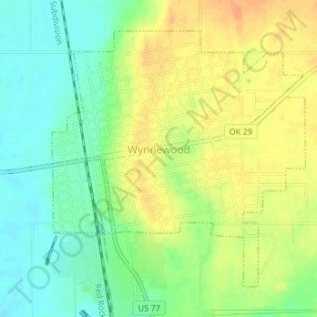
Name: Wynnewood topographic map, elevation, terrain.
Location: Wynnewood, Garvin County, Oklahoma, 73098, United States (34.63167 -97.17555 34.65353 -97.14925)
Average elevation: 271 m
Minimum elevation: 252 m
Maximum elevation: 290 m
Other topographic maps
Click on a map to view its topography, its elevation and its terrain.
Paoli
United States > Oklahoma > Garvin County
Paoli, Garvin County, Oklahoma, 73074, United States
Average elevation: 289 m
Elmore City
United States > Oklahoma > Garvin County
Elmore City, Garvin County, Oklahoma, United States
Average elevation: 302 m
Stratford
United States > Oklahoma > Garvin County
Stratford, Garvin County, Oklahoma, 74872, United States
Average elevation: 340 m
Erin Springs
United States > Oklahoma > Garvin County
Erin Springs, Garvin County, Oklahoma, United States
Average elevation: 306 m
Katie
United States > Oklahoma > Garvin County
Katie, Garvin County, Oklahoma, United States
Average elevation: 291 m
Pernell
United States > Oklahoma > Garvin County
Pernell, Garvin County, Oklahoma, United States
Average elevation: 307 m
Hennepin
United States > Oklahoma > Garvin County
Hennepin, Garvin County, Oklahoma, 73444, United States
Average elevation: 289 m
Foster
United States > Oklahoma > Garvin County
Foster, Garvin County, Oklahoma, United States
Average elevation: 308 m
Wallville
United States > Oklahoma > Garvin County
Wallville, Garvin County, Oklahoma, United States
Average elevation: 318 m
Purdy
United States > Oklahoma > Garvin County
Purdy, Garvin County, Oklahoma, United States
Average elevation: 329 m
Maysville
United States > Oklahoma > Garvin County
Maysville, Garvin County, Oklahoma, United States
Average elevation: 292 m
Lindsay
United States > Oklahoma > Garvin County
Lindsay, Garvin County, Oklahoma, United States
Average elevation: 300 m
Pauls Valley
United States > Oklahoma > Garvin County
Pauls Valley, Garvin County, Oklahoma, United States
Average elevation: 275 m