
Thank you for supporting this site ❤️
Make a donation
Make a donation
Marsabit topographic map
Click on the map to display elevation.
Thank you for supporting this site ❤️
Make a donation
Make a donation
Marsabit
Marsabit is a town in the northern Marsabit County in Kenya. It is situated in the former Eastern Province and is almost surrounded by the Marsabit National Park. The town is located 170 kilometres (110 mi) east of the centre of the East African Rift at an elevation of between 1300 and 1400 metres. It serves as the capital of Marsabit County, and lies southeast of the Chalbi Desert in a forested area known for its volcanoes and crater lakes.
Thank you for supporting this site ❤️
Make a donation
Make a donation
About this map
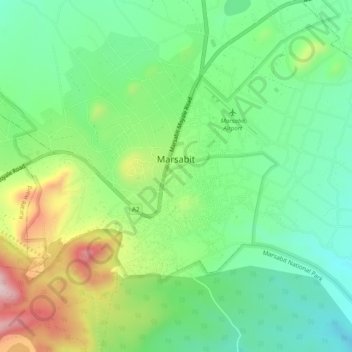
Name: Marsabit topographic map, elevation, terrain.
Location: Marsabit, Saku, Marsabit County, Eastern, 60500, Kenya (2.32151 37.96415 2.34976 38.01335)
Average elevation: 1,346 m
Minimum elevation: 1,209 m
Maximum elevation: 1,608 m
Thank you for supporting this site ❤️
Make a donation
Make a donation