
Thank you for supporting this site ❤️
Make a donation
Make a donation
Tulis topographic map
Click on the map to display elevation.
Thank you for supporting this site ❤️
Make a donation
Make a donation
About this map
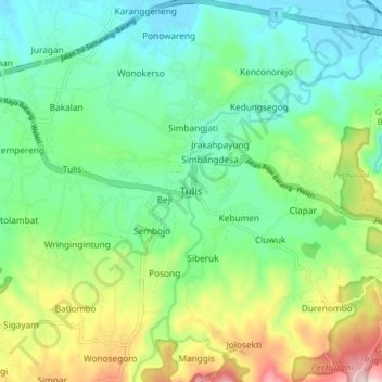
Name: Tulis topographic map, elevation, terrain.
Location: Tulis, Batang, Central Java, Java, 51261, Indonesia (-6.99183 109.76785 -6.91183 109.84785)
Average elevation: 101 m
Minimum elevation: 2 m
Maximum elevation: 325 m
Thank you for supporting this site ❤️
Make a donation
Make a donation
Other topographic maps
Click on a map to view its topography, its elevation and its terrain.