
Make a donation
Binghamton topographic map
Click on the map to display elevation.
Make a donation
Binghamton
Binghamton, like all of the Southern Tier of New York, lies on the Allegheny Plateau; hence its hilly terrain. As such, elevations can vary in the city--Downtown, for example, is at an elevation of around 860 feet (262 meters), while residential homes in the hills can go up to over 1,800 feet (548 meters), such as on Ingram Hill. The highest peak in Binghamton is Table Rock Ridge, which is at 1,854 feet.
Make a donation
About this map
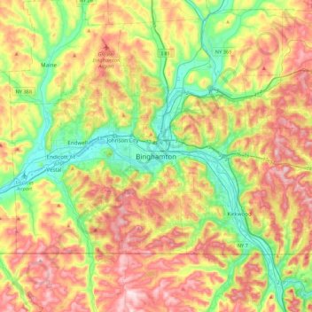
Name: Binghamton topographic map, elevation, terrain.
Average elevation: 397 m
Minimum elevation: 242 m
Maximum elevation: 597 m
Make a donation
Other topographic maps
Click on a map to view its topography, its elevation and its terrain.
State University of New York at Binghamton
United States > New York > Broome County > Town of Vestal
Average elevation: 320 m
Make a donation
Susquehanna River
United States > New York > Broome County > Town of Kirkwood
Average elevation: 411 m
Make a donation
Kopernik Observatory & Science Center
United States > New York > Broome County > Town of Vestal > Tracy Creek
Average elevation: 452 m
Make a donation
Oquaga Creek State Park
United States > New York > Broome County > Town of Sanford
Average elevation: 533 m