
Make a donation
Hightstown topographic map
Click on the map to display elevation.
Make a donation
About this map
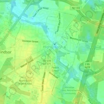
Name: Hightstown topographic map, elevation, terrain.
Location: Hightstown, Mercer County, New Jersey, United States (40.25775 -74.53760 40.27863 -74.51386)
Average elevation: 34 m
Minimum elevation: 23 m
Maximum elevation: 42 m
Make a donation
Other topographic maps
Click on a map to view its topography, its elevation and its terrain.
Twin Rivers
United States > New Jersey > Mercer County > East Windsor Township
Average elevation: 35 m
Make a donation
Make a donation
Make a donation
Princeton Colonial Park
United States > New Jersey > Mercer County > Princeton Colonial Park
Average elevation: 29 m
Hamilton Square
United States > New Jersey > Mercer County > Hamilton Township > Hamilton Square
Average elevation: 29 m
Make a donation
Chewalla Park
United States > New Jersey > Mercer County > Hamilton Township > Chewalla Park
Average elevation: 21 m
Van Nest Park
United States > New Jersey > Mercer County > West Windsor > Old Mill Farms
Average elevation: 27 m
Make a donation