
Make a donation
Engis topographic map
Click on the map to display elevation.
Make a donation
Engis
In late 1930 and early 1931, several thousand cases of acute pulmonary attacks occurred in the Meuse valley, centered on Engis, and 60 people died. A commission of inquiry set up by the Belgian government concluded that the cause was poisonous waste gases, primarily sulfur dioxide, emitted by the many factories in the valley and the furnaces used by the population, in conjunction with unusual climatic conditions coupled with the unique topographic characteristics of the area. Others have claimed that the deaths were the result acute fluorine intoxication.
Make a donation
About this map
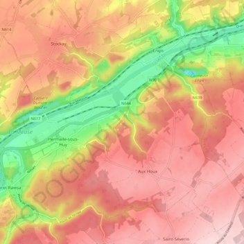
Name: Engis topographic map, elevation, terrain.
Location: Engis, Huy, Liège, Wallonia, 4480, Belgium (50.53189 5.33365 50.59305 5.44069)
Average elevation: 171 m
Minimum elevation: 25 m
Maximum elevation: 264 m
Make a donation
Other topographic maps
Click on a map to view its topography, its elevation and its terrain.
Make a donation
Make a donation
Make a donation