
Hingene topographic map
Interactive map
Click on the map to display elevation.
About this map
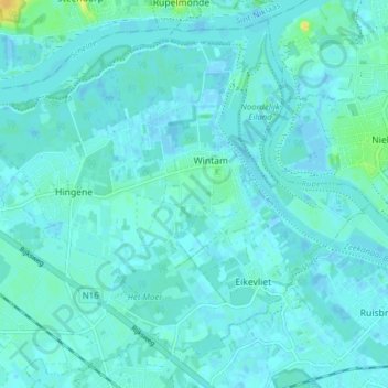
Name: Hingene topographic map, elevation, terrain.
Location: Hingene, Bornem, Mechelen, Antwerpen, 2889, België (51.08049 4.24911 51.12506 4.32826)
Average elevation: 3 m
Minimum elevation: -3 m
Maximum elevation: 23 m
Other topographic maps
Click on a map to view its topography, its elevation and its terrain.
Buitenland
België > Antwerpen > Mechelen > Bornem
Buitenland, Bornem, Mechelen, Antwerpen, Vlaanderen, 2880, België
Average elevation: 6 m
Mariekerke
België > Antwerpen > Mechelen > Bornem
Mariekerke, Bornem, Mechelen, Antwerpen, Vlaanderen, België
Average elevation: 4 m