
Thank you for supporting this site ❤️
Make a donation
Make a donation
Cabeza del Caballo topographic map
Click on the map to display elevation.
Thank you for supporting this site ❤️
Make a donation
Make a donation
About this map
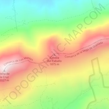
Name: Cabeza del Caballo topographic map, elevation, terrain.
Average elevation: 1,562 m
Minimum elevation: 1,139 m
Maximum elevation: 2,016 m
Thank you for supporting this site ❤️
Make a donation
Make a donation
Other topographic maps
Click on a map to view its topography, its elevation and its terrain.
Sierra de Huétor
España > Andalucía > Comarca de la Vega de Granada > Huétor de Santillán
Average elevation: 1,426 m