
Sunspot topographic map
Click on the map to display elevation.
Sunspot
The origins of Sunspot as a Solar Observatory date back to the sudden increased interest of solar physics to the US military during the Second World War. In 1940, the High Altitude Observatory (HAO) was established in 1940 in Climax, Colorado, by Walter Orr Roberts and Donald Menzel. It was associated with both Harvard College Observatory and the University of Colorado and was incorporated in 1946. At the time it was the world's highest permanent observatory for astronomy, at an elevation of over 11,000 feet, and was designed purely for studying the Sun. Roberts worked with the Bureau of Standards, "forecasting radio conditions on the basis of solar observations". Such studies of the upper atmosphere were critical for predicting conditions for radio communication, guided missiles, and supersonic aircraft and, as a result, solar observations "became essential to the war effort". Suddenly the field of solar astronomy became an appealing goal for both astronomers and the military.
About this map
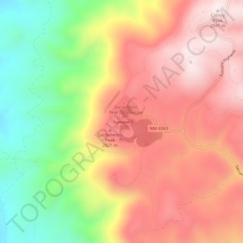
Name: Sunspot topographic map, elevation, terrain.
Location: Sunspot, Otero County, New Mexico, 88349, United States (32.76921 -105.83857 32.80921 -105.79857)
Average elevation: 2,626 m
Minimum elevation: 2,243 m
Maximum elevation: 2,932 m
Other topographic maps
Click on a map to view its topography, its elevation and its terrain.
Alamogordo
United States > New Mexico > Otero County
As of 2010, Alamogordo had a total area of 19.3 square miles (50.0 km2), all of it land. The city is located at an elevation of 4,336 feet (1,322 m) on the western flank of the Sacramento Mountains and on the eastern edge of the Tularosa Basin. It lies within the Rio Grande rift and in the northernmost part of…
Average elevation: 1,515 m
Cloudcroft
United States > New Mexico > Otero County
Cloudcroft is a village in Otero County, New Mexico, United States, and is located within the Lincoln National Forest. The population was 674 at the 2010 census. Despite being located in an otherwise arid region, its high elevation (8,676 feet (2,644 m); one of the highest in the U.S.) allows for a mild summer…
Average elevation: 2,643 m
La Luz
United States > New Mexico > Otero County
The largest employer in the surrounding area is Holloman Air Force Base. La Luz itself is largely residential and agricultural in land use but a small market is located on the state maintained road that connects the village to Highway 70. La Luz has long been known for the many fruits that are grown in the…
Average elevation: 1,487 m
Timberon
United States > New Mexico > Otero County
Timberon is located at 32°37′54″N 105°41′32″W / 32.63167°N 105.69222°W / 32.63167; -105.69222 (32.631675, -105.692254). Timberon is located in a forested valley, known as Sacramento Canyon, on the southern slopes of the Sacramento Mountains. The Sacramento Creek, an intermittent creek,…
Average elevation: 2,181 m
White Sands National Park
United States > New Mexico > Otero County
The first US Army exploration of south-central New Mexico was led by a party of topographical engineering officers in 1849. They passed west of the San Andres Mountains and Organ Mountains. A lieutenant was dispatched east across the basin with a scouting party to map a potential military wagon route to the…
Average elevation: 1,214 m
Alamogordo
United States > New Mexico > Otero County
As of 2010, Alamogordo had a total area of 19.3 square miles (50.0 km2), all of it land. The city is located at an elevation of 4,336 feet (1,322 m) on the western flank of the Sacramento Mountains and on the eastern edge of the Tularosa Basin. It lies within the Rio Grande rift and in the northernmost part of…
Average elevation: 1,427 m
Timberon
United States > New Mexico > Otero County
Timberon is located in a forested valley, known as Sacramento Canyon, on the southern slopes of the Sacramento Mountains. The Sacramento Creek, an intermittent creek, flows southeast through the valley. The community extends up several crosscutting canyons including Arkansas Canyon, Graveyard Canyon and…
Average elevation: 2,217 m
White Sands National Park
United States > New Mexico > Otero County
The first US Army exploration of south-central New Mexico was led by a party of topographical engineering officers in 1849. They passed west of the San Andres Mountains and Organ Mountains. A lieutenant was dispatched east across the basin with a scouting party to map a potential military wagon route to the…
Average elevation: 1,214 m
Cloudcroft
United States > New Mexico > Otero County
Cloudcroft is a village in Otero County, New Mexico, United States, and is located within the Lincoln National Forest. The population was 674 at the 2010 census. Despite being located in an otherwise arid region, its high elevation (8,676 feet (2,644 m) allows for a mild summer and forested surroundings that…
Average elevation: 2,643 m
Alamogordo
United States > New Mexico > Otero County
As of 2010, Alamogordo had a total area of 19.3 square miles (50.0 km2), all land. The city is located at an elevation of 4,330 feet (1,320 m) on the western flank of the Sacramento Mountains and on the eastern edge of the Tularosa Basin. It lies within the Rio Grande rift and in the northernmost part of the…
Average elevation: 1,427 m
Cloudcroft
United States > New Mexico > Otero County
Its high elevation of 8,676 feet (2,644 m) allows for a mild summer, and the forested mountains make it a tourist attraction for the surrounding deserts. Tourism is the primary economy of the village.
Average elevation: 2,643 m
La Luz
United States > New Mexico > Otero County
The largest employer in the surrounding area is Holloman Air Force Base. La Luz itself is largely residential and agricultural in land use but a small market is located on the state maintained road that connects the village to Highway 70. La Luz has long been known for the many fruits that are grown in the…
Average elevation: 1,487 m