
Thank you for supporting this site ❤️
Make a donation
Make a donation
Roseland topographic map
Click on the map to display elevation.
Thank you for supporting this site ❤️
Make a donation
Make a donation
About this map
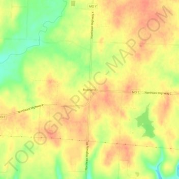
Name: Roseland topographic map, elevation, terrain.
Location: Roseland, Henry County, Missouri, United States (38.37335 -93.56243 38.41335 -93.52243)
Average elevation: 243 m
Minimum elevation: 213 m
Maximum elevation: 257 m
Thank you for supporting this site ❤️
Make a donation
Make a donation
Other topographic maps
Click on a map to view its topography, its elevation and its terrain.
Thank you for supporting this site ❤️
Make a donation
Make a donation
Thank you for supporting this site ❤️
Make a donation
Make a donation