
Thank you for supporting this site ❤️
Make a donation
Make a donation
Hog Lake topographic map
Click on the map to display elevation.
Thank you for supporting this site ❤️
Make a donation
Make a donation
About this map
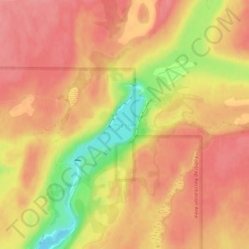
Name: Hog Lake topographic map, elevation, terrain.
Location: Hog Lake, Spokane County, Washington, United States (47.37376 -117.80965 47.38140 -117.79833)
Average elevation: 664 m
Minimum elevation: 605 m
Maximum elevation: 689 m
Thank you for supporting this site ❤️
Make a donation
Make a donation
Other topographic maps
Click on a map to view its topography, its elevation and its terrain.
Thank you for supporting this site ❤️
Make a donation
Make a donation
Medical Lake
United States > Washington > Spokane County > Medical Lake > Medical Lake
Average elevation: 747 m
Thank you for supporting this site ❤️
Make a donation
Make a donation