
Thank you for supporting this site ❤️
Make a donation
Make a donation
Cascade Shores topographic map
Click on the map to display elevation.
Thank you for supporting this site ❤️
Make a donation
Make a donation
About this map
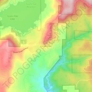
Name: Cascade Shores topographic map, elevation, terrain.
Location: Cascade Shores, Nevada County, California, United States (39.24273 -120.92557 39.28273 -120.88557)
Average elevation: 978 m
Minimum elevation: 776 m
Maximum elevation: 1,185 m
Thank you for supporting this site ❤️
Make a donation
Make a donation
Other topographic maps
Click on a map to view its topography, its elevation and its terrain.