
Thank you for supporting this site ❤️
Make a donation
Make a donation
Village topographic map
Click on the map to display elevation.
Thank you for supporting this site ❤️
Make a donation
Make a donation
About this map
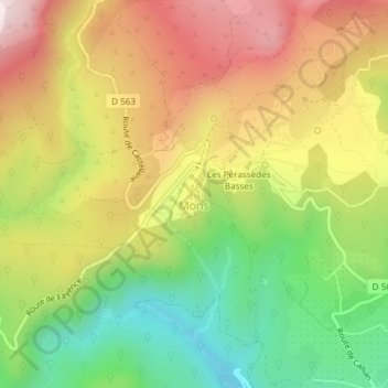
Name: Village topographic map, elevation, terrain.
Average elevation: 769 m
Minimum elevation: 481 m
Maximum elevation: 1,070 m
Thank you for supporting this site ❤️
Make a donation
Make a donation
Other topographic maps
Click on a map to view its topography, its elevation and its terrain.
Lachens
France > Provence-Alpes-Côte d'Azur > Var > Mons
La montagne de Lachens est le point culminant du département du Var avec ses 1 712 m d'altitude, elle est située sur la commune de Mons. Elle est aussi la limite géographique et climatique de la Côte d'Azur et du climat méditerranéen, laissant la place aux Alpes et au climat montagnard. L'accès au…
Average elevation: 1,364 m