
Thank you for supporting this site ❤️
Make a donation
Make a donation
Brandy Hill topographic map
Click on the map to display elevation.
Thank you for supporting this site ❤️
Make a donation
Make a donation
About this map
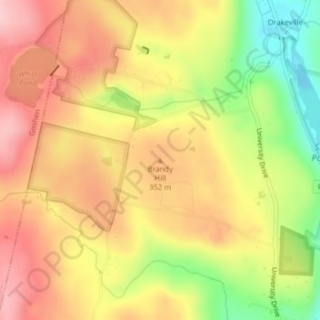
Name: Brandy Hill topographic map, elevation, terrain.
Average elevation: 325 m
Minimum elevation: 217 m
Maximum elevation: 404 m
Thank you for supporting this site ❤️
Make a donation
Make a donation
Other topographic maps
Click on a map to view its topography, its elevation and its terrain.
Burr Pond State Park
United States > Connecticut > Litchfield County > Torrington > Burrville
Average elevation: 322 m