
Thank you for supporting this site ❤️
Make a donation
Make a donation
Lockyer Valley Regional topographic map
Click on the map to display elevation.
Thank you for supporting this site ❤️
Make a donation
Make a donation
About this map
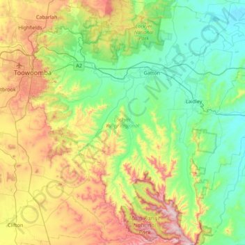
Name: Lockyer Valley Regional topographic map, elevation, terrain.
Location: Lockyer Valley Regional, Queensland, Australia (-27.97753 151.94202 -27.38523 152.51866)
Average elevation: 360 m
Minimum elevation: 48 m
Maximum elevation: 1,118 m
Thank you for supporting this site ❤️
Make a donation
Make a donation
Other topographic maps
Click on a map to view its topography, its elevation and its terrain.