
Winterville topographic map
Interactive map
Click on the map to display elevation.
About this map
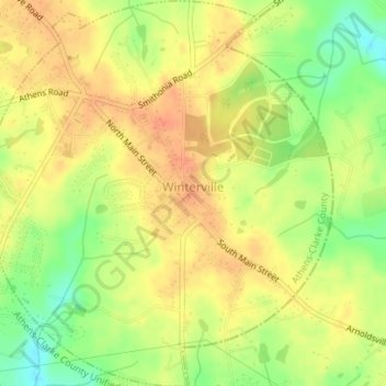
Name: Winterville topographic map, elevation, terrain.
Average elevation: 235 m
Minimum elevation: 209 m
Maximum elevation: 251 m
Other topographic maps
Click on a map to view its topography, its elevation and its terrain.
Spring Valley Estates
United States > Georgia > Athens-Clarke County > Athens-Clarke County Unified Government
Spring Valley Estates, Athens-Clarke County Unified Government, Athens-Clarke County, Georgia, 30601, United States
Average elevation: 218 m
Athens-Clarke County Unified Government
United States > Georgia > Athens-Clarke County
Athens-Clarke County Unified Government, Athens-Clarke County, Georgia, United States
Average elevation: 219 m
Eastmeadow
United States > Georgia > Athens-Clarke County > Athens-Clarke County Unified Government
Eastmeadow, Athens-Clarke County Unified Government, Athens-Clarke County, Georgia, 30605, United States
Average elevation: 223 m
Jefferson Valley
United States > Georgia > Athens-Clarke County > Athens-Clarke County Unified Government
Jefferson Valley, Athens-Clarke County Unified Government, Athens-Clarke County, Georgia, 30607, United States
Average elevation: 223 m
Rollingwood
United States > Georgia > Athens-Clarke County > Athens-Clarke County Unified Government
Rollingwood, Athens-Clarke County Unified Government, Athens-Clarke County, Georgia, 30608, United States
Average elevation: 210 m
Shoal Creek Farms
United States > Georgia > Athens-Clarke County > Athens-Clarke County Unified Government
Shoal Creek Farms, Athens-Clarke County Unified Government, Athens-Clarke County, Georgia, United States
Average elevation: 205 m
Moss Side
United States > Georgia > Athens-Clarke County > Athens > Moss Side
Moss Side, Athens, Athens-Clarke County, Georgia, 30603, United States
Average elevation: 221 m