
Thank you for supporting this site ❤️
Make a donation
Make a donation
Long'an County topographic map
Click on the map to display elevation.
Thank you for supporting this site ❤️
Make a donation
Make a donation
About this map
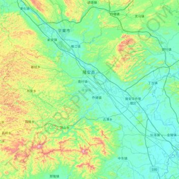
Name: Long'an County topographic map, elevation, terrain.
Location: Long'an County, Nanning, Guangxi, China (22.84582 107.32456 23.35239 108.08722)
Average elevation: 255 m
Minimum elevation: 66 m
Maximum elevation: 1,003 m
Thank you for supporting this site ❤️
Make a donation
Make a donation
Other topographic maps
Click on a map to view its topography, its elevation and its terrain.
Thank you for supporting this site ❤️
Make a donation
Make a donation