
Make a donation
Clifton topographic map
Click on the map to display elevation.
Make a donation
About this map
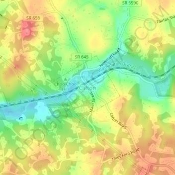
Name: Clifton topographic map, elevation, terrain.
Location: Clifton, Fairfax County, Virginia, United States (38.77528 -77.39290 38.78517 -77.38023)
Average elevation: 87 m
Minimum elevation: 50 m
Maximum elevation: 121 m
Make a donation
Other topographic maps
Click on a map to view its topography, its elevation and its terrain.
Make a donation
George Washington's Mount Vernon
United States > Virginia > Fairfax County > Mount Vernon
Visitors to Mount Vernon now see Washington's study, a room to which in the 18th century only a privileged few were granted entry. This simply furnished room has a combined bathroom, dressing room and office; the room was so private that few contemporary descriptions exist. Its walls are lined with naturally…
Average elevation: 14 m
Izaak Walton League of America - Arlington-Fairfax Chapter
United States > Virginia > Fairfax County > Centreville
Average elevation: 72 m
Make a donation
Make a donation
Make a donation
Mount Vernon Community Park
United States > Virginia > Fairfax County > Fort Hunt > Snowden
Average elevation: 14 m
Make a donation
Shirley Gate Park
United States > Virginia > Fairfax County > George Mason > Shirley Gate Park
Average elevation: 128 m
Make a donation