
Make a donation
Doklam topographic map
Click on the map to display elevation.
Make a donation
Doklam
Through this exploration, Bell discovered that the prevailing border between Bhutan and Tibet to the west of Amo Chu was a highland tree (Ya-shing) – lowland tree (Mön-shing) border over the same geographic region. The highland trees belonged to Tibet, perhaps above 11,500 ft in elevation, while the lowland trees belonged to Bhutan.
Make a donation
About this map
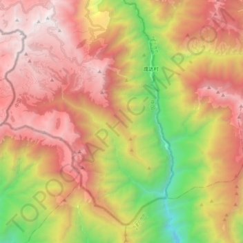
Name: Doklam topographic map, elevation, terrain.
Average elevation: 3,192 m
Minimum elevation: 1,517 m
Maximum elevation: 4,639 m
Make a donation
Other topographic maps
Click on a map to view its topography, its elevation and its terrain.
Nathu La
China > Tibet > Yadong County > Xiayadong
Nathu La is a mountain pass on the Dongkya Range that separates Sikkim and the Chumbi Valley at an elevation of 14,250 feet (4,340 m). The pass is 52–54 kilometres (32–34 mi) east of Gangtok, the capital of Sikkim, and 35 kilometres (22 mi) from Yatung Shasima, the headquarters of the Yadong County (or the…
Average elevation: 4,240 m