
Make a donation
Dubuque topographic map
Click on the map to display elevation.
Make a donation
Dubuque
Dubuque (/dəˈbjuːk/ , dəb-YOOK) is a city in Dubuque County, Iowa, United States, and its county seat. The population was 59,667 at the 2020 United States census. The city lies along the Mississippi River at the junction of Iowa, Illinois, and Wisconsin, a region locally known as the Tri-State Area. It serves as the main commercial, industrial, educational, and cultural center for the area. Geographically, it is part of the Driftless Area, a portion of North America that escaped all three phases of the Wisconsin Glaciation, resulting in a hilly topography unlike most of the Midwestern United States.
Make a donation
About this map
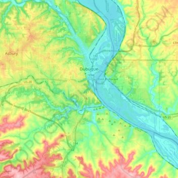
Name: Dubuque topographic map, elevation, terrain.
Location: Dubuque, Dubuque County, Iowa, United States (42.40926 -90.82402 42.55790 -90.63673)
Average elevation: 241 m
Minimum elevation: 178 m
Maximum elevation: 353 m
Make a donation
Other topographic maps
Click on a map to view its topography, its elevation and its terrain.
Mississippi River
United States > Iowa > Dubuque County > Dubuque > Eagle Point
The uppermost lock and dam on the Upper Mississippi River is the Upper St. Anthony Falls Lock and Dam in Minneapolis. Above the dam, the river's elevation is 799 feet (244 m). Below the dam, the river's elevation is 750 feet (230 m). This 49-foot (15 m) drop is the largest of all the Mississippi River locks…
Average elevation: 200 m