
Make a donation
Aragon topographic map
Click on the map to display elevation.
Make a donation
Aragon
There are two main types of climate in Aragón, the Semi-arid climate and the Oceanic climate. Its irregular orography creates several microclimates throughout the entire community. From the High mountain Alpine climate of the central Pyrenees to the north, with perpetual ice (glaciers), to the Humid subtropical climate (which is very common in Huesca's lower altitude areas) to the steppe or semi-desert zones, such as the Monegros Desert, passing through the intense continental climate of the Teruel-Daroca area and the Mediterranean climate in the southern areas bordering Castilla La Mancha and the Valencian Community.
Make a donation
About this map
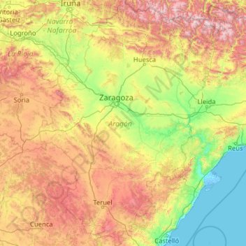
Name: Aragon topographic map, elevation, terrain.
Location: Aragon, Spain (39.84678 -2.17367 42.92450 0.77131)
Average elevation: 778 m
Minimum elevation: -5 m
Maximum elevation: 3,311 m
Make a donation
Other topographic maps
Click on a map to view its topography, its elevation and its terrain.
Make a donation
Make a donation
Make a donation
Arrutiegia
Spain > Autonomous Community of the Basque Country > Urola-Kosta > Aia
Average elevation: 223 m
Make a donation
Las Vagas
Spain > Aragon > Cuencas Mineras > Martín del Río > La Rambla de Martín
Average elevation: 1,120 m
Make a donation
Urbanització Cala Llonga
Spain > Balearic Islands > Ibiza > Santa Eulària des Riu
Average elevation: 39 m
Make a donation
Make a donation
Make a donation
Donostia / San Sebastián
Spain > Autonomous Community of the Basque Country > Donostialdea > Donostia / San Sebastián
Average elevation: 134 m
Make a donation
Madrid
Spain > Community of Madrid > Área metropolitana de Madrid y Corredor del Henares > Madrid
Average elevation: 650 m
Make a donation
Murcia
Spain > Region of Murcia > Region of Murcia > Murcia
Murcia is located near the center of a low-lying fertile plain known as the huerta (orchard or vineyard) of Murcia. The Segura River and its right-hand tributary, the Guadalentín, run through the area. The city has an elevation of 43 metres (141 ft) above sea level and its municipality covers approximately…
Average elevation: 169 m
Make a donation
El Port de la Selva
Spain > Catalonia > Upper Empordà > el Port de la Selva > El Port de la Selva
Average elevation: 76 m
Make a donation
Pollença
Spain > Balearic Islands > Serra de Tramuntana > Pollença > Pollença
Average elevation: 156 m
Make a donation
Make a donation
Presa de Majarobledo
Spain > Extremadura > Las Hurdes > Casares de las Hurdes
Average elevation: 1,080 m