
Thank you for supporting this site ❤️
Make a donation
Make a donation
Qorğaljın topographic map
Click on the map to display elevation.
Thank you for supporting this site ❤️
Make a donation
Make a donation
Qorğaljın
The village is located on the Kazakh Uplands. The average altitude in the village is about 330 meters above sea level. The terrain is a continuous plain with small hills and water areas.
Thank you for supporting this site ❤️
Make a donation
Make a donation
About this map
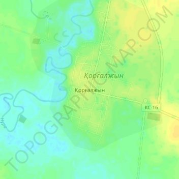
Name: Qorğaljın topographic map, elevation, terrain.
Location: Qorğaljın, Qorğaljın district, Akmola Region, Kazakhstan (50.56371 69.99796 50.60371 70.03796)
Average elevation: 330 m
Minimum elevation: 321 m
Maximum elevation: 340 m
Thank you for supporting this site ❤️
Make a donation
Make a donation