
Thank you for supporting this site ❤️
Make a donation
Make a donation
Lookout topographic map
Click on the map to display elevation.
Thank you for supporting this site ❤️
Make a donation
Make a donation
About this map
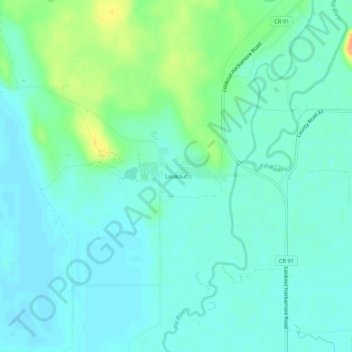
Name: Lookout topographic map, elevation, terrain.
Location: Lookout, Modoc County, California, 96054, United States (41.18794 -121.17525 41.22794 -121.13525)
Average elevation: 1,266 m
Minimum elevation: 1,257 m
Maximum elevation: 1,293 m
Thank you for supporting this site ❤️
Make a donation
Make a donation
Other topographic maps
Click on a map to view its topography, its elevation and its terrain.