
Make a donation
Falcón topographic map
Click on the map to display elevation.
Make a donation
About this map
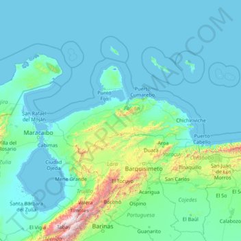
Name: Falcón topographic map, elevation, terrain.
Location: Falcón, Región Centroccidental, Venezuela (8.40000 -72.43333 13.60000 -67.23333)
Average elevation: 209 m
Minimum elevation: -5 m
Maximum elevation: 4,623 m
Make a donation
Other topographic maps
Click on a map to view its topography, its elevation and its terrain.
Falcon State
Falcón State is located in the north of the Corian System. To the south, Falcón contains medium-altitude mountain ranges configured from east to west, which in the eastern part of the state reach the Caribbean Sea, forming maritime valleys.
Average elevation: 221 m
Make a donation
Miranda State
The hydrography of Miranda State is characterized by the short course and low flow of its rivers, with the exception of Tuy. This characteristic, combined with the settlement of the largest mass of population in the country, gives its rivers great significance as sources of water for urban consumption. The Tuy…
Average elevation: 255 m
Portugal Abajo
Venezuela > Anzoategui State > Municipio Simón Bolívar > Barcelona
Average elevation: 7 m
Make a donation
Anzoategui State
The vegetation of the Anzoátegui State is typical temperate. It is largely determined by altitude, climate and season of the year, where areas of snow-covered scrub, cujíes and small southern species alternate. It also has a tree called caderoms, this includes resistant or environmentally adapted varieties.
Average elevation: 156 m
Make a donation
Make a donation