
Thank you for supporting this site ❤️
Make a donation
Make a donation
Grobnik topographic map
Click on the map to display elevation.
Thank you for supporting this site ❤️
Make a donation
Make a donation
About this map
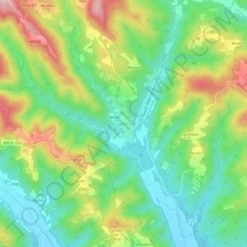
Name: Grobnik topographic map, elevation, terrain.
Location: Grobnik, Općina Pićan, Istria County, 52233, Croatia (45.21763 14.07333 45.25763 14.11333)
Average elevation: 134 m
Minimum elevation: 32 m
Maximum elevation: 306 m
Thank you for supporting this site ❤️
Make a donation
Make a donation
Other topographic maps
Click on a map to view its topography, its elevation and its terrain.