
Thank you for supporting this site ❤️
Make a donation
Make a donation
Slide Mountain Wilderness topographic map
Click on the map to display elevation.
Thank you for supporting this site ❤️
Make a donation
Make a donation
Slide Mountain Wilderness
Within its boundaries lie 10 of the 35 Catskill High Peaks, including the highest Catskill peak, Slide, 4,180 feet (1277 m) of elevation; and lowest, Rocky.
Thank you for supporting this site ❤️
Make a donation
Make a donation
About this map
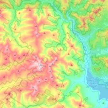
Name: Slide Mountain Wilderness topographic map, elevation, terrain.
Average elevation: 584 m
Minimum elevation: 174 m
Maximum elevation: 1,262 m
Thank you for supporting this site ❤️
Make a donation
Make a donation