
Thank you for supporting this site ❤️
Make a donation
Make a donation
Tinghir topographic map
Click on the map to display elevation.
Thank you for supporting this site ❤️
Make a donation
Make a donation
Tinghir
Tinghir is an oasis about 30 kilometres (19 mi) long and about 4 kilometres (2.5 mi) wide. The climate is arid subtropical: hot, dry winters in relation to altitude (1,430 metres (4,690 ft)). There are a few rainy days per year, with the greatest precipitation in fall and winter.
Thank you for supporting this site ❤️
Make a donation
Make a donation
About this map
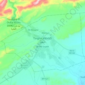
Name: Tinghir topographic map, elevation, terrain.
Average elevation: 1,352 m
Minimum elevation: 1,198 m
Maximum elevation: 2,045 m
Thank you for supporting this site ❤️
Make a donation
Make a donation