
Thank you for supporting this site ❤️
Make a donation
Make a donation
Hautes-Alpes topographic map
Click on the map to display elevation.
Thank you for supporting this site ❤️
Make a donation
Make a donation
Hautes-Alpes
Hautes-Alpes is located in the Alps mountain range. The average elevation is over 1000 m, and the highest elevation is over 4000 m. The only three sizable towns are Gap, Briançon, and Embrun, which was a subprefecture until 1926.
Thank you for supporting this site ❤️
Make a donation
Make a donation
About this map
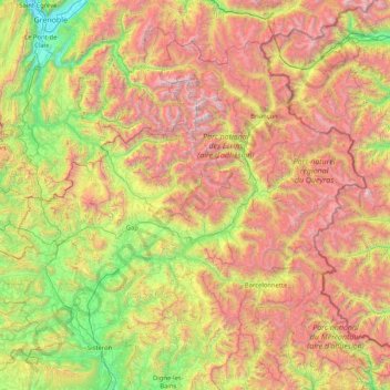
Name: Hautes-Alpes topographic map, elevation, terrain.
Average elevation: 1,631 m
Minimum elevation: 198 m
Maximum elevation: 3,955 m
Thank you for supporting this site ❤️
Make a donation
Make a donation