
Make a donation
Ioannina topographic map
Click on the map to display elevation.
Make a donation
Ioannina
Ioannina (Greek: Ιωάννινα Ioánnina [i.oˈa.ni.na] (listen)), often called Yannena (Γιάννενα Yánnena [ˈʝa.ne.na]) within Greece, is the capital and largest city of the Ioannina regional unit and of Epirus, an administrative region in north-western Greece. According to the 2011 census, the city population was 65,574, while the municipality had 112,486 inhabitants. It lies at an elevation of approximately 500 metres (1,640 feet) above sea level, on the western shore of Lake Pamvotis (Παμβώτις). Ioannina is located 410 km (255 mi) northwest of Athens, 260 kilometres (162 miles) southwest of Thessaloniki and 80 km (50 miles) east of the port of Igoumenitsa in the Ionian Sea.
Make a donation
About this map
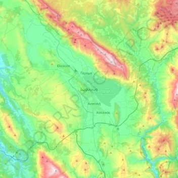
Name: Ioannina topographic map, elevation, terrain.
Average elevation: 724 m
Minimum elevation: 270 m
Maximum elevation: 1,804 m
Make a donation
Other topographic maps
Click on a map to view its topography, its elevation and its terrain.
Vikos–Aoos National Park
Greece > Epirus > Ioannina Regional Unit
The Vikos–Aoös National Park (Greek: Εθνικός Δρυμός Βίκου–Αώου, romanized: Ethnikós Drymós Víkou–Aóou) is a national park in the region of Epirus in northwestern Greece. The park, founded in 1973, is one of ten national parks in mainland Greece and is located 30 kilometres (19…
Average elevation: 1,147 m