
Thank you for supporting this site ❤️
Make a donation
Make a donation
Sungai Beduk topographic map
Click on the map to display elevation.
Thank you for supporting this site ❤️
Make a donation
Make a donation
About this map
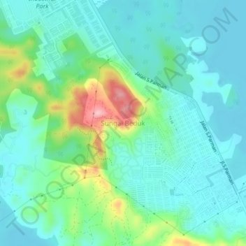
Name: Sungai Beduk topographic map, elevation, terrain.
Location: Sungai Beduk, Batam, Riau Islands, Sumatra, 29437, Indonesia (1.02017 104.02348 1.06017 104.06348)
Average elevation: 39 m
Minimum elevation: -2 m
Maximum elevation: 166 m
Thank you for supporting this site ❤️
Make a donation
Make a donation
Other topographic maps
Click on a map to view its topography, its elevation and its terrain.