
Thank you for supporting this site ❤️
Make a donation
Make a donation
Shelbyville topographic map
Click on the map to display elevation.
Thank you for supporting this site ❤️
Make a donation
Make a donation
About this map
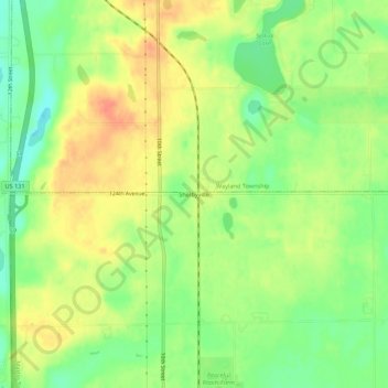
Name: Shelbyville topographic map, elevation, terrain.
Average elevation: 251 m
Minimum elevation: 226 m
Maximum elevation: 273 m
Thank you for supporting this site ❤️
Make a donation
Make a donation
Other topographic maps
Click on a map to view its topography, its elevation and its terrain.
Allegan State Game Area
United States > Michigan > Allegan County > Plainwell
Average elevation: 217 m
Thank you for supporting this site ❤️
Make a donation
Make a donation
Thank you for supporting this site ❤️
Make a donation
Make a donation
Thank you for supporting this site ❤️
Make a donation
Make a donation