
Thank you for supporting this site ❤️
Make a donation
Make a donation
Sholam topographic map
Click on the map to display elevation.
Thank you for supporting this site ❤️
Make a donation
Make a donation
About this map
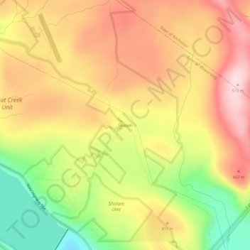
Name: Sholam topographic map, elevation, terrain.
Average elevation: 383 m
Minimum elevation: 215 m
Maximum elevation: 515 m
Thank you for supporting this site ❤️
Make a donation
Make a donation
Other topographic maps
Click on a map to view its topography, its elevation and its terrain.
Bear Hill Preserve (Cragsmoor Free Library)
United States > New York > Ulster County > Town of Wawarsing > Cragsmoor
Average elevation: 414 m