
Town of Farmington topographic map
Interactive map
Click on the map to display elevation.
About this map
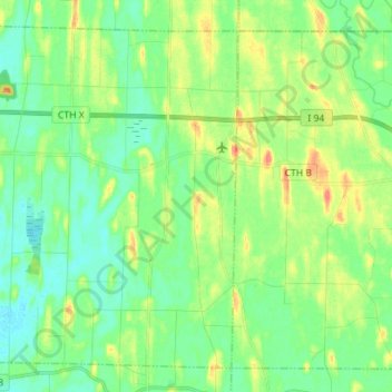
Name: Town of Farmington topographic map, elevation, terrain.
Average elevation: 260 m
Minimum elevation: 243 m
Maximum elevation: 294 m
Other topographic maps
Click on a map to view its topography, its elevation and its terrain.
Lake Koshkonong
United States > Wisconsin > Jefferson County > Town of Koshkonong
Lake Koshkonong, Town of Koshkonong, Town of Sumner, Jefferson County, Wisconsin, United States
Average elevation: 244 m
Lake Ripley
United States > Wisconsin > Jefferson County
Lake Ripley, Jefferson County, Wisconsin, United States
Average elevation: 262 m
Town of Watertown
United States > Wisconsin > Jefferson County
Town of Watertown, Jefferson County, Wisconsin, United States
Average elevation: 260 m
Kettle Moraine State Forest - South
United States > Wisconsin > Jefferson County
Kettle Moraine State Forest - South, Town of Palmyra, Jefferson County, Wisconsin, 53501, United States
Average elevation: 274 m
Jefferson
United States > Wisconsin > Jefferson County
Jefferson, Jefferson County, Wisconsin, 53549, United States
Average elevation: 251 m
Sullivan
United States > Wisconsin > Jefferson County
Sullivan, Jefferson County, Wisconsin, 53178, United States
Average elevation: 262 m
Hebron
United States > Wisconsin > Jefferson County
Hebron, Town of Hebron, Jefferson County, Wisconsin, United States
Average elevation: 251 m
Lake Mills
United States > Wisconsin > Jefferson County
Lake Mills, Jefferson County, Wisconsin, 53551, United States
Average elevation: 256 m
Ixonia
United States > Wisconsin > Jefferson County > Ixonia
Ixonia, Town of Ixonia, Jefferson County, Wisconsin, United States
Average elevation: 261 m
Town of Koshkonong
United States > Wisconsin > Jefferson County
Town of Koshkonong, Jefferson County, Wisconsin, 53538, United States
Average elevation: 251 m
Palmyra
United States > Wisconsin > Jefferson County
Palmyra, Jefferson County, Wisconsin, 53156, United States
Average elevation: 258 m
Town of Jefferson
United States > Wisconsin > Jefferson County
Town of Jefferson, Jefferson County, Wisconsin, 53137, United States
Average elevation: 252 m
Watertown
United States > Wisconsin > Jefferson County
Watertown, Jefferson County, Wisconsin, 53094, United States
Average elevation: 258 m
Town of Sullivan
United States > Wisconsin > Jefferson County
Town of Sullivan, Jefferson County, Wisconsin, United States
Average elevation: 261 m
Town of Aztalan
United States > Wisconsin > Jefferson County
Town of Aztalan, Jefferson County, Wisconsin, United States
Average elevation: 253 m
Rome
United States > Wisconsin > Jefferson County > Rome
Rome, Town of Sullivan, Jefferson County, Wisconsin, United States
Average elevation: 258 m
Town of Milford
United States > Wisconsin > Jefferson County
Town of Milford, Jefferson County, Wisconsin, United States
Average elevation: 249 m
Town of Oakland
United States > Wisconsin > Jefferson County
Town of Oakland, Jefferson County, Wisconsin, United States
Average elevation: 266 m
Fort Atkinson
United States > Wisconsin > Jefferson County
Fort Atkinson, Jefferson County, Wisconsin, United States
Average elevation: 249 m
Waterloo
United States > Wisconsin > Jefferson County
Waterloo, Jefferson County, Wisconsin, 53594, United States
Average elevation: 257 m
Johnson Creek
United States > Wisconsin > Jefferson County
Johnson Creek, Jefferson County, Wisconsin, 53038, United States
Average elevation: 249 m
Aztalan State Park
United States > Wisconsin > Jefferson County > Town of Aztalan
Aztalan State Park, Town of Aztalan, Jefferson County, Wisconsin, United States
Average elevation: 255 m