
Thank you for supporting this site ❤️
Make a donation
Make a donation
Murray City topographic map
Click on the map to display elevation.
Thank you for supporting this site ❤️
Make a donation
Make a donation
About this map
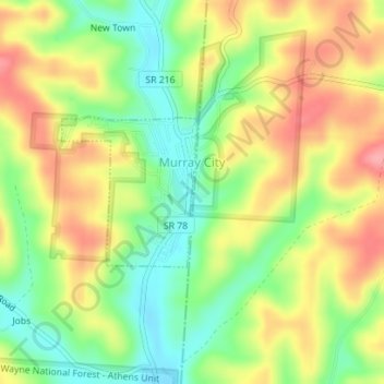
Name: Murray City topographic map, elevation, terrain.
Location: Murray City, Hocking County, Ohio, 43144, United States (39.50404 -82.17538 39.51464 -82.16299)
Average elevation: 257 m
Minimum elevation: 209 m
Maximum elevation: 307 m
Thank you for supporting this site ❤️
Make a donation
Make a donation
Other topographic maps
Click on a map to view its topography, its elevation and its terrain.
Thank you for supporting this site ❤️
Make a donation
Make a donation
Thank you for supporting this site ❤️
Make a donation
Make a donation
Thank you for supporting this site ❤️
Make a donation
Make a donation
Thank you for supporting this site ❤️
Make a donation
Make a donation
Thank you for supporting this site ❤️
Make a donation
Make a donation
Hocking Hills State Park Mountain Bike Trail Head
United States > Ohio > Hocking County
Average elevation: 306 m