
Thank you for supporting this site ❤️
Make a donation
Make a donation
Dale Abbey topographic map
Click on the map to display elevation.
Thank you for supporting this site ❤️
Make a donation
Make a donation
About this map
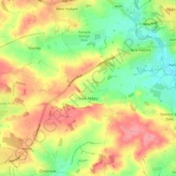
Name: Dale Abbey topographic map, elevation, terrain.
Location: Dale Abbey, Erewash, Derbyshire, England, United Kingdom (52.92638 -1.41483 52.96724 -1.32483)
Average elevation: 89 m
Minimum elevation: 43 m
Maximum elevation: 134 m
Thank you for supporting this site ❤️
Make a donation
Make a donation
Other topographic maps
Click on a map to view its topography, its elevation and its terrain.