
Thank you for supporting this site ❤️
Make a donation
Make a donation
McCullough topographic map
Click on the map to display elevation.
Thank you for supporting this site ❤️
Make a donation
Make a donation
About this map
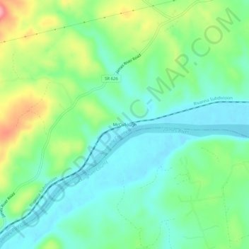
Name: McCullough topographic map, elevation, terrain.
Location: McCullough, Albemarle County, Virginia, United States (37.73709 -78.63529 37.77709 -78.59529)
Average elevation: 123 m
Minimum elevation: 87 m
Maximum elevation: 202 m
Thank you for supporting this site ❤️
Make a donation
Make a donation
Other topographic maps
Click on a map to view its topography, its elevation and its terrain.
Thank you for supporting this site ❤️
Make a donation
Make a donation
Thank you for supporting this site ❤️
Make a donation
Make a donation
Thank you for supporting this site ❤️
Make a donation
Make a donation