
Thank you for supporting this site ❤️
Make a donation
Make a donation
Brook Hill topographic map
Click on the map to display elevation.
Thank you for supporting this site ❤️
Make a donation
Make a donation
About this map
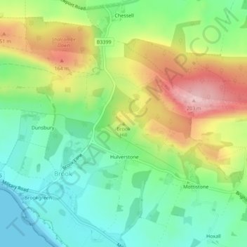
Name: Brook Hill topographic map, elevation, terrain.
Average elevation: 77 m
Minimum elevation: 0 m
Maximum elevation: 199 m
Thank you for supporting this site ❤️
Make a donation
Make a donation
Other topographic maps
Click on a map to view its topography, its elevation and its terrain.
Isle of Wight National Landscape
United Kingdom > England > Isle of Wight > Brighstone
Average elevation: 18 m