
Thank you for supporting this site ❤️
Make a donation
Make a donation
Las Abieras topographic map
Click on the map to display elevation.
Thank you for supporting this site ❤️
Make a donation
Make a donation
About this map
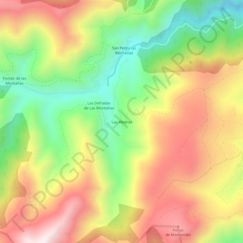
Name: Las Abieras topographic map, elevation, terrain.
Location: Las Abieras, Cangas del Narcea, Asturias, España (43.12519 -6.68551 43.16519 -6.64551)
Average elevation: 921 m
Minimum elevation: 528 m
Maximum elevation: 1,322 m
Thank you for supporting this site ❤️
Make a donation
Make a donation
Other topographic maps
Click on a map to view its topography, its elevation and its terrain.