
大王滩水库 topographic map
Interactive map
Click on the map to display elevation.
About this map
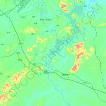
Name: 大王滩水库 topographic map, elevation, terrain.
Location: 大王滩水库, 良庆区, 南宁市, 广西壮族自治区, 中国 (22.38775 108.23400 22.60349 108.32450)
Average elevation: 137 m
Minimum elevation: 79 m
Maximum elevation: 344 m
Other topographic maps
Click on a map to view its topography, its elevation and its terrain.