
Thank you for supporting this site ❤️
Make a donation
Make a donation
Barangay 78 topographic map
Click on the map to display elevation.
Thank you for supporting this site ❤️
Make a donation
Make a donation
About this map
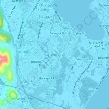
Name: Barangay 78 topographic map, elevation, terrain.
Location: Barangay 78, Tacloban, Eastern Visayas, 6500, Philippines (11.18255 124.98562 11.22255 125.02562)
Average elevation: 8 m
Minimum elevation: -1 m
Maximum elevation: 186 m
Thank you for supporting this site ❤️
Make a donation
Make a donation
Other topographic maps
Click on a map to view its topography, its elevation and its terrain.