
Thank you for supporting this site ❤️
Make a donation
Make a donation
Lake Mead topographic map
Click on the map to display elevation.
Thank you for supporting this site ❤️
Make a donation
Make a donation
About this map
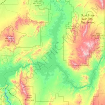
Name: Lake Mead topographic map, elevation, terrain.
Location: Lake Mead, Clark County, Nevada, United States (36.00097 -114.83948 36.43337 -114.09881)
Average elevation: 684 m
Minimum elevation: 201 m
Maximum elevation: 1,726 m
Thank you for supporting this site ❤️
Make a donation
Make a donation
Other topographic maps
Click on a map to view its topography, its elevation and its terrain.