
Thank you for supporting this site ❤️
Make a donation
Make a donation
Platania topographic map
Click on the map to display elevation.
Thank you for supporting this site ❤️
Make a donation
Make a donation
About this map
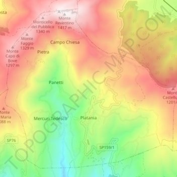
Name: Platania topographic map, elevation, terrain.
Location: Platania, Catanzaro, Calabria, Italy (38.98840 16.28387 39.04209 16.36045)
Average elevation: 865 m
Minimum elevation: 305 m
Maximum elevation: 1,402 m
Thank you for supporting this site ❤️
Make a donation
Make a donation
Other topographic maps
Click on a map to view its topography, its elevation and its terrain.